The Challenges and Advances of Using Seismic Data to Predict Earthquakes
Introduction
Earthquakes are among the most devastating natural disasters, striking with little to no warning and causing massive loss of life and infrastructure damage. Scientists and engineers have long sought to develop reliable methods to predict earthquakes before they occur using seismic data. While exact earthquake prediction remains difficult, recent advances in analyzing seismic data have led to improvements in hazard assessments and early warning systems. This article will explore the scientific principles behind seismic monitoring, highlight specific projects and their applications, and include their real-world impact.
Scientific Principles
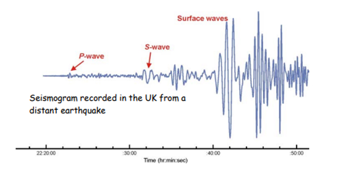
First, let's begin with understanding seismology. Seismology is the study of earthquakes and how elastic waves travel through the Earth. It provides the basic framework for earthquake prediction. Typically, seismic data include measurements of ground vibrations recorded with seismometers. By analyzing patterns in seismic waves, such as primary waves, which travel the fastest, and secondary waves, scientists can locate the epicenter of an earthquake and estimate its magnitude.
However, predicting exactly when and where an earthquake will occur before it actually happens is significantly more complicated. Earthquakes occur due to a sudden release of buildup of tectonic stress along faults. The challenge lies in detecting subtle changes like small foreshocks, changes in fault zone properties, or crustal shifts. These signs might signal an upcoming earthquake. In recent years, the use of seismic data combined with satellite observations, GPS measurements, and machine learning models is being employed to identify these warning signs.
Specific Applications and Examples
Let's look at a specific application of seismic data: the development of earthquake early warning systems. Currently, Japan’s meteorological agency runs Japan’s nationwide EEW system, where they analyze real-time seismic data to detect P-waves. Since P-waves travel faster but cause less damage than slower S-waves, the system can send early alerts seconds before the S-waves arrive. This provides people more time to take cover and allows trains and factories to stop safely.
In the US, the US Geological Survey manages the ShakeAlert system along with several universities. This system uses hundreds of ground sensors across the West Coast to send warnings through mobile apps and automated systems. It has the potential to save lives in densely populated cities like Los Angeles and San Francisco.
Beyond early warnings, seismic data are also crucial for long-term hazard assessments. For example, the Global Seismic Hazard Assessment Program collects seismic records and geological data to create hazard maps based on probability. This helps engineers and city planners build earthquake-resistant infrastructure.
Machine learning has also become a powerful tool, enabling researchers to analyze large seismic datasets for patterns that humans might miss. Projects like the Stanford Earthquake Machine Learning (SEML) group use algorithms to detect previously unnoticed foreshocks or slow slip events, providing new insights into fault behavior.
Finally, machine learning has become a very useful tool for analyzing large seismic datasets for patterns that scientists and engineers might overlook. Projects like the Stanford Earthquake ML group use algorithms to detect unnoticed foreshocks or slow slip events. This offers many benefits, such as insights into fault behavior.
Conclusion
Although accurately predicting earthquakes—pinpointing the exact time, location, and size—is practically impossible due to the complexity of geological systems, seismic data have already changed how we reduce earthquake risks. Early warning systems provide vital time that can help save many lives, and seismic hazard assessments assist engineers and planners in designing safer cities. As technology continues to advance—such as the development of combined seismic monitoring with AI, satellite imagery, and interdisciplinary research—these advancements bring us closer to achieving the goal of making the world a safer place from the dangers of earthquakes.
Resources
- USGS Earthquake Program
- International Seismological Centre
- Frontiers in Earth Science: ML for Seismology
- Japan Meteorological Agency – EEW
- USGS – Earthquake Early Warning
- SRL: Earthquake Early Warning in Japan
- Stanford Earthquake (SEML) Group
- Nature Reviews: Earthquake Forecasting & Hazard
- ETHZ – GSHAP
- USGS – Probabilistic Seismic Hazard Analysis

Leave Feedback!